
Becoming a SoilOptix® service provider is an exciting opportunity to deliver high-resolution soil mapping as part of advanced precision agriculture services. This article outlines what’s required—from equipment and training to data management and client support—to help you succeed in offering this innovative solution.
High-resolution soil data has become one of the most critical assets in modern agronomic and land management strategies. Yet the sophistication behind each SoilOptix® map lies not only in the technology but in the expertise and fieldwork of those who deploy it. Whether you’re a senior agronomist expanding your precision portfolio, a consultant entering the turf management space, or a service provider looking to differentiate your offering—this post outlines the skillset, operational readiness, and strategic mindset required to succeed.
Becoming a SoilOptix® Service Provider: It Starts with a Commitment to Technical Mastery
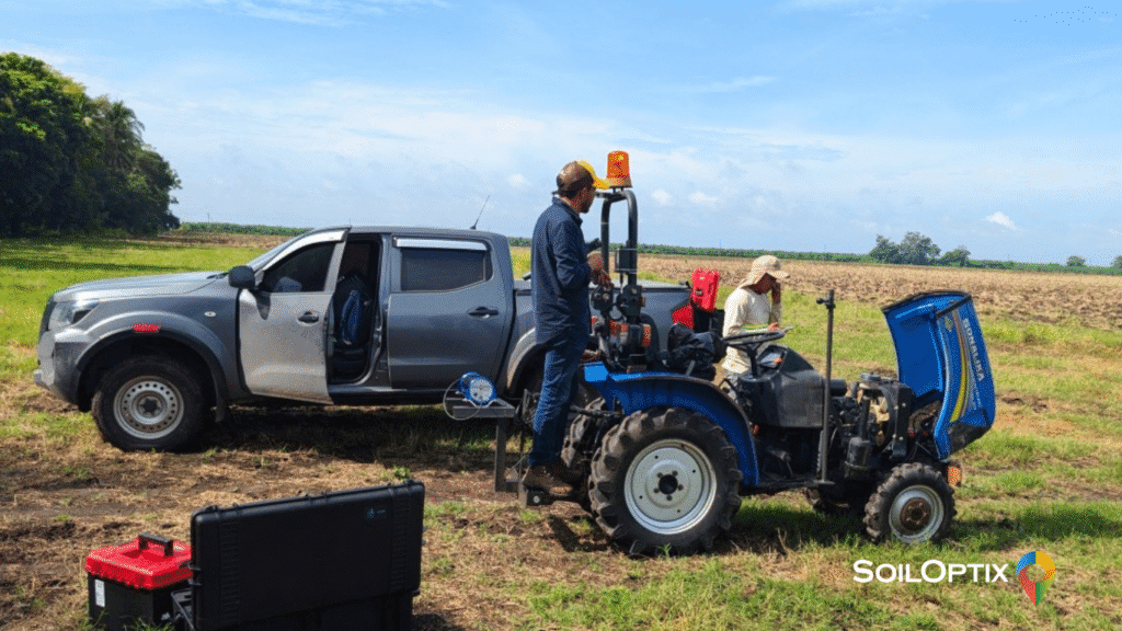
Becoming a SoilOptix® service provider doesn’t demand decades of experience, but it does require a serious commitment to understanding the system’s scientific and operational underpinnings. Our most effective partners come from diverse disciplines—agronomy, turf science, soil ecology, precision ag—but share a drive to master the methodology and apply it with discipline. The system leverages RTK GPS for sub-centimeter accuracy, so familiarity with GPS operations ensures high-quality data capture. As we say, good data starts in the field.
Core Infrastructure: Tools and Readiness
Our system is adaptable across a variety of landscapes and business models, but success hinges on logistical preparedness. A capable provider will typically maintain:
- A reliable vehicle or UTV adapted to their field conditions. Terrain varies from row-crop fields to manicured turfgrass. Your vehicle should enable efficient, consistent scanning under pressure.
- Professional-grade soil sampling tools. Accuracy in sampling directly influences data integrity. Providers either execute this with training or coordinate with trained partners.
- Spatial awareness and GPS fluency. Field navigation isn’t about simply covering ground—it’s about ensuring spatial precision and minimizing overlap or gaps.
- Digital competence. While SoilOptix® provides robust processing support, familiarity with data workflows—including file types such as shapefiles (SHP), CSVs, and GeoTIFFs—accelerates delivery and troubleshooting.
- Adaptability to various land uses. The SoilOptix® system is highly flexible and applicable across almost every crop type and land use scenario. One day you may be scanning cornfields; the next, it could be vineyards, orchards, golf courses, or sports fields. Each brings its own operational dynamics and learning curve.
- Data management practices. Providers must be able to interpret soil data, handle large high-resolution datasets effectively, and translate results into actionable strategies such as variable rate application (VRA) plans. Establishing reliable processes for data handling ensures scalability and in-field impact.
There’s No Archetype—Only Alignment
Our partner network is intentionally diverse. As we expand into non-traditional markets, we see high-performing providers emerging from irrigation firms, turf consultants, and tech-savvy entrepreneurs. This evolution reinforces one truth: success is less about fitting a mold and more about aligning your strengths with a scalable, insight-driven service model.
During onboarding, we work with you to map out your opportunity space based on your core competencies and clientele.
Common Operational Barriers—and How We Help You Navigate Them
Service providers often encounter predictable but manageable friction points:
- Seasonal constraints. The scanning window is highly time sensitive. While the SoilOptix® system offers more flexibility than many alternatives, soil scanning typically happens post-harvest or pre-planting. Success depends on agile workflows and rapid mobilization.
- Market education. Many customers are unfamiliar with high-resolution mapping. Providers must be able to clearly communicate the differentiators and long-term value.
- Resource balancing. Many of our providers operate multiple service lines. Operational agility—especially in peak seasons—is key to sustainability.
- Environmental and topographic variability. From unpredictable weather to irregular topographies, field conditions require adaptable field strategy and good judgment.
We equip you with technical resources, marketing support, and advisory guidance to address these challenges before they become constraints.
Strategic Gains: The Business and Agronomic Case
For Providers:
- Expanded revenue channels. Our technology unlocks premium service tiers, especially when integrated with VR nutrients, seed, or amendment strategies.
- Client stickiness. By delivering measurable impact on yield or input ROI, you elevate your role from vendor to strategic advisor.
- Credibility and visibility. Providing high-resolution data puts you ahead of competitors who rely on traditional sampling methods.
For End Users:
- Unmatched data clarity. With over 25 soil layers mapped at square-meter resolution, decision-making becomes far more precise.
- Input optimization. Prescription accuracy directly improves both economic return and environmental stewardship.
- Evidence-based planning. Multi-year mapping enables longitudinal soil management and sustainability tracking.
Final Word: Partnership over Platform
SoilOptix® is not plug-and-play technology, it’s a performance model built on collaboration, shared standards, and continuous support. We don’t just supply the tools; we invest in our partners. If you’re ready to deliver a high-value, data-rich service with measurable agronomic impact, our team is here to get you operational—and competitive.
Curious about becoming a SoilOptix® service provider? Let’s start a conversation.