The developing practice of precision farming has been making waves in the agriculture sector. Fueled by recent technological advancements, innovations transform traditional farming methods into highly analytical processes. Precision agriculture (PA) is an agricultural management strategy that uses cutting-edge technologies and tools to gather, process and analyze information to enhance farm assessment and provide optimized agricultural input applications, considering crop and soil needs for improving productivity.
Understanding precision agriculture
Precision Agriculture involves observing, measuring, and then responding to various inter and intra-field variability inputs for modern-day agriculture.
The popular definitions of Precision Agriculture (PA) or Site-Specific Crop Management (SSCM) describe the term as a technology-powered approach to agriculture management. Precision agriculture aims to increase efficiency and productivity, reduce input costs, and improve environmental sustainability.
Soil and crop parameters are spatially variable in a field. Spatial variability is the within-field variation of a parameter, that is, the difference between its value measured in an area and its averaged value in the field. In these conditions, spatially uniform rate crop input applications cause increased environmental impact and crop input waste.
To reduce the environmental impact and optimize the use of crop inputs, precision agriculture was born: it is the geo-referenced application of crop inputs, whose rates must be those required by the crop.

As the agricultural landscape changes – literally and figuratively – so will your technology needs, on and off the farm
The undeniable importance of Precision Agriculture
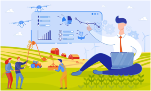
Farmers can control all the processes remotely with a precision agriculture system. Even small farms can manage large fields or a group of small areas.
It dramatically improves the efficiency of crops and saves financial costs while increasing production. The last aspect is essential since precision agriculture technologies are costly at first glance. However, the savings are significantly higher in the long run than traditional agricultural methods. So, growers can accurately sum the required fertilizer amount and determine effective fertilizer types for a particular area. Moreover, precision farming technologies are essential because they improve the planning of agricultural operations for an extended period, adjusting the real-time strategy during force majeure.
Optimizing the soil use preserves its quality, enabling a stable food supply. Therefore, precision farming in agriculture plays an essential part in solving the global hunger problem.

Source: Freepik
Advantages of Precision Agriculture
By using precision agriculture technologies and practices, farmers can target their inputs to specific areas that need them the most rather than simply applying them uniformly across the entire field.
This targeted approach to agriculture can help farmers save on inputs and increase crop yield and quality. In addition, precision agriculture technologies can help farmers monitor and manage their crops more efficiently, allowing them to respond to potential problems like pest infestations or diseases more swiftly and effectively.
Farmers can leverage the sensors and mapping tools to apply fertilizers at the correct rate and location. In addition, precision ag technologies can also help farmers optimize their irrigation practices, saving water and energy.
Since details of different areas in a single farm can also be traced, precision agriculture benefits farmers in several ways:
- A refined set of agricultural practices and choice of crops depending on the suitability of land
- Elimination of volatility and risk
- Waste management
- Reduced production costs
- Minimum environmental impact
- Optimized use of fertilizers
- Water management with optimized irrigation practices
- Improved soil health
The precision agriculture cycle
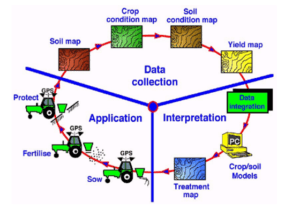
The precision agriculture cycle consists of the following stages:
- measurement of within-field spatially variable soil and crop parameters and monitoring of local weather conditions (data collection)
- mapping of within-field soil and crop parameters (data collection)
- mapping of spatially variable rate crop input applications (interpretation)
- spatially variable rate crop input applications (application)

Source: Researchgate.net
The tools and technologies of Precision Agriculture
Anyone looking for the perfect precision agriculture solution should know the tools and technologies available. Let us dive into the different tools and technologies needed for precision agriculture.
1) Global Positioning System (GPS)
The Global Positioning System popularly known as GPS is a satellite-based navigation system that looks for crucial details like location and time information in all the weather conditions, anywhere on or near the Earth. In precision agriculture, GPS provides accurate location information for mapping and navigation reasons.
One of the main ways GPS is employed in precision agriculture is for farm mapping and field-level data collection. Agriculturists can use GPS receivers mounted on top of their vehicles or equipment to collect data on the location of the spot, shape, and size of their fields and the location of specific features within the areas, like the irrigation systems, drainage ditches, and the fence lines. This data can be used to create more detailed maps of the farmlands, which can be employed for planning and scheduling field operations, implementing variable rate technology in agricultural management, and analyzing the field performance.
2) Geographic Information System (GIS)
A geographical information system or GIS consists of a computer software database system employed to input, archive, retrieve, analyze and display, in map-like form, referenced geographical information.
In precision agriculture, GIS creates, stores, and analyzes spatial data related to farming operations, like the field boundaries, topography, soil and crop variants, and other features. Farmers can also use GIS to identify the most ideal locations for planting certain crops or areas most vulnerable to pest infestations or diseases.
3) Grid Sampling for targeted farming
Grid sampling is a process for segmenting fields into about 0.5–5 ha-sized units. Those grids’ soil testing samples will be used to calculate crop input application rates. The Grid Samples are then gathered, combined, and delivered to the lab for evaluation.
Grid sampling can collect soil samples from different parts of a field to understand the spatial variations of soil characteristics. This information can be used to make well-informed decisions about fertilization, cropping, irrigation, etc.
4) Variable-Rate Technology (VRT)
Variable-rate technology (VRT) comprises of farm equipment that can precisely control the degree of application of crop inputs that can also be varied in their application, including soil tillage, insect control, fertilizer application, plant population, and irrigation.
VRT is based on the idea that different field parts may have different soil types, topography, crop characteristics, and other factors affecting their input requirements. Using VRT, farmers can optimize resource use and improve efficiency and productivity.
5) Yield Monitors for Precision Agriculture
A yield monitor is a device used in precision agriculture to evaluate and record crop yields as they get harvested. Yield monitors typically consist of smart sensors that measure the flow of grain as they pass through the combine harvester and a data recording device that records the yield data.
Yield monitors can create detailed maps of the crop yields across a plot showing the spatial variations of outcomes and identifying areas performing poorly or well.
Yield monitors can measure and record the quality of the harvested crops, like moisture content and test weight. This information can also be used to optimize storage and handling practices and improve the produce’s overall quality.
6) Yield Maps
Data from an adapted combined harvester with a GPS integrated on a yield tracking system is processed to get the yield maps. A yield map visualizes crop yields across a plot, showing the spatial variability of yields and spotting areas that are performing poorly or well. Besides the yield monitors, these maps can also be created using other data gathering tools like GPS or remote sensing technologies.
Yield maps can help farmers maximize their resource management practices by identifying field areas with different resource needs. They can also support planning and decision-making by providing a clear visual and spatial context for data analysis.
7) Remote Sensors
Remote sensors are generally segregated as aerial or satellite sensors. Changes in the soil type, crop development, the field boundaries, roads, water, etc., can also indicate differences in field colour. Remote science, in agricultural context, means viewing crops ideally from a satellite or low-flying aircraft without coming into contact, recording what is considered and displaying the image, and creating the map to pinpoint the different field problems earlier and more effectively.
8) Auto-Guidance Systems
Auto-guidance systems are precision agriculture technologies that use GPS and other sensors to help the farmers navigate their vehicles and farming equipment around the fields with high accuracy.
These systems usually consist of a GPS receiver, a display unit, and sometimes other sensors that provide additional information about the field and the vehicle’s position.
9) Proximal Sensors for accurate crop and soil data capturing
Proximal sensors can measure soil (N and pH) and crop properties as the tractor moves over the agricultural field.
Proximal sensors are sensors used in precision agriculture to measure the properties of the crops or soil close to the sensor. The soil sample is scooped and then pressed against an electrode, then a stabilization period of about 10-15 seconds is allowed, and after that the reading is taken. These sensors can be hand-held or easily mounted on vehicles or other agricultural equipment. Proximalte sensors are typically used to collect data on a real-time or near-real-time basis, allowing the farmers to respond to the changing conditions and adjust as needed.
10) Computer Hardware and Software
Computer support is always required to analyze the data gathered by other components of precision farming technology and to make it in accessible in formats like the maps, graphs, or charts, or reports.
a. Data storage and management systems
Precision agriculture solutions often generate huge amounts of data, that must be stored and managed in a systematic, structured, and efficient manner. This can be done using various data storage and management systems, like databases and cloud-based platforms.
b. Data analysis and visualization tools
Precision agriculture systems often require specialized software tools to analyze and visualize data to extract insights and make informed decisions.
4Rs of Nutrient Stewardship in Precision Agriculture
The 4 R Nutrient Stewardship principles of PA include: applying the Right Source, at the Right Amount, to the Right Place, and at Right Time.
Right Source
Optimizing the use of agricultural inputs can sometimes mean minimizing them. The goal is to increase the farm system’s capacity and efficiency to maximize production and profit while improving environmental quality and sustainability.
Right Rate
Identifying the field variations and determining the right amount of Input is required to optimize agriculture practices that utilize variable-rate input applications instead of uniform applications to improve input use efficiency.
Right Time
Many factors, including the plant’s growth stage, climatic conditions, crop nutrient uptake, and field operation logistics, may influence the correct application time. The correct application time will improve crop performance and reduce the environmental risk level associated with agricultural practices.
Right Place
Appropriate placement of nutrient fertilizers may affect their uptake and nutrient use efficiency. Correct nitrogen placement, for example, can reduce N loss to tile drainage and decrease volatilization, considering the plant root distribution and N source, soil dynamics, nutrient movement, and managing spatial variability within a field.
In conclusion
The global precision farming market is almost estimated to reach about $12.84 billion by 2026. Both the big and small farmers and organizations working with the growers benefit by adopting the precision and digital farming technologies, which aid to maximize Agri-input resources without adding to the costs or workload. With climate change affecting farming in a big way, unpredictable natural disasters like the floods and drought becoming the regular events, and the world population escalating unabated, precision agriculture is here to stay.
You can contact experts if you have any questions about precision agriculture. Get in touch with our experts at SoilOptix® today!
